

Too Much Gray
WE KINDLY ASK THAT THESE QUESTIONS BE ANSWERED, DOCUMENTATION PROVIDED, AND CONDITIONS BE MORE RESTRICTIVE:
NOISE POLLUTION STUDY
RIGOROUS NOISE ORDINANCES WHICH EXCEED SURROUNDING COUNTY NOISE ORDINANCES
LIGHT POLLUTION STUDY
VIBRATION STUDY
SEWER STUDY AND APPROVAL FROM SURROUNDING TOWNS/COUNTIES
WATER STUDY AND CRISIS PLAN FOR WATER USAGE DURING DROUGHT
RESEARCH LONG TERM EFFECTS OF DATA CENTERS ONCE THEIR USEFUL LIFE IS OVER. THESE ARE MASSIVE BUILDINGS SPECIFICALLY DESIGNED FOR A PARTICULAR USE. WHAT NEXT? WHO PAYS FOR THE CLEAN UP WHEN THE CENTER SITS EMPTY? ROUGHLY ONE SQUARE MILE AND 1.5 MILLION SQUARE FEET OF BUILDING FOOTPRINT OVER A WATERSHED
LEGALLY BINDING ASSURANCE THAT BOTH CODDLE CREEK AND THE WATERSHED/AQUIFER WATER WILL NOT BE TOUCHED
LEGALLY BINDING ASSURANCE THAT TRACT AND THE DATA CENTER WILL BE SOLELY RESPONSIBLE FOR ANY WASTE CLEAN UP AND ASSOCIATED COSTS
TRUE RENDERING OF DATA CENTER WITH DIMENSIONS
SPECIFIC HEIGHT - MAXIMUM BUILDING HEIGHT ABOVE GROUND 35'
NATURAL BUFFERS INCREASED TO 900'
NO BACK UP GENERATOR USAGE AFTER 9 PM - SEE NOISE POLLUTION
DOCUMENT FROM DUKE ENERGY WITH AGREEMENT THAT RESIDENTIAL CUSTOMERS ENERGY IS A PRIORITY OVER DATA CENTER ENERGY
DOCUMENT FROM DUKE ENERGY WITH AGREEMENT THAT RESIDENTIAL CUSTOMERS WILL NOT RECEIVE RATE INCREASED DUE TO DATA CENTER'S ENERGY USAGE
DISCLOSURE OF PROJECT TO CABARRUS, ROWAN, AND MECKLENBURG COUNTIES WITH PARTICULAR EMPHASIS ON COMMUNICATING NEED FOR ALL PERSONS INVOLVED TO DO THEIR DUE DILLIGENCE AND RESEARCH DATA CENTERS
INFORMATION ABOUT THE TRUE NUMBER OF LONG TERM JOBS AND SPECIFIC SKILLSETS NEEDED FOR SHORT TERM CONSTRUCTION JOBS
APPRAISAL DATA FROM THE CHARLOTTE AREA REGARDING THE EFFECT OF THE DATA CENTER ON PROPERTY VALUE; BOTH FOR ADJACENT PROPERTIES AND PROPERTIES THAT WILL BE AFFECTED BY NOISE OR LIGHT POLLUTION
TRAFFIC STUDY WITH CONSIDERATION TO ROUTE 3 NEEDS
NO ALLOWANCE FOR METHANE GAS/MULTIPLE GENERATORS/GAS TURBINES
NO ALLOWANCE FOR GLYCOLS TO BE USED AS LEAKAGE COULD AFFECT AQUIFER AND DON HOWELL RESERVOIR
CLOSE INSPECTION OF ANTI-CORROSION CHEMICALS USED IN WATER
NO ADDED TRANSMISSION LINES
We respectfully request greater transparency and clarity on the projected financial outcomes, incentive structures related to this project, projected water use and waste water details, and categorization of data center
Specifically, we would appreciate your assistance in addressing the following:
Fiscal Impact and Revenue Projections:
Has the Town conducted a 20-year fiscal impact analysis for this project? If so, could you please share the study or the financial model used to justify the development?
What assumptions and projections were used in modeling future revenue, and are these available for public review?
Has the Town considered or conducted a third-party or independent review to ensure the assumptions are realistic and unbiased?
HAS THE TOWN INVESTIGATED SPECIFICS AS TO WHAT AND WHAT IS NOT TAXED AS REAL ESTATE ASSESSMENT IS VERY OFTEN THE ONLY GUARANTEED TAX REVENUE? EX. FEDERAL WORK WILL EXEMPT DATA CENTER FROM TAXES ON EQUIPMENT
HAS THE TOWN RESEARCHED OBSOLESCENCE PROJECTIONS FROM THIRD PARTIES? 5-10 YEARS
WHAT WILL BE THE TOWN'S COST FOR INFASTRUCTURE VS TAX REVENUE AS MANY TOWNS ARE IN THE RED FOR MANY YEARS? PARTIAL VS FULL BUILD OUT REVENUE.
Incentives and Their Long-Term Impact:
What is the total value of incentives being offered to the developer over the next 20 years?
How does this figure impact the net tax revenue expected from the project?
Are the incentives being offered performance-based, and if so, what metrics (e.g., job creation, capital investment) will be used to measure compliance?
Will the Town include clawback provisions in the event that the company fails to meet its commitments?
Given the scope and scale of the proposed development, residents deserve a full understanding of both the potential benefits and the financial trade-offs. These are critical questions for evaluating whether the project aligns with the long-term interests of our community.
Water:
Will it be potable water, wastewater or a combination of the two?
What special considerations are the developer requesting to ensure adequate water supply if the primary or single source of water is to be supplied by the Town of Mooresville?
What actions will the Town of Mooresville take to mitigate the water supply limitations? Options may include a building moratorium, water use restrictions, negotiating with Duke Energy to increase the supply from Lake Norman, expanding supply by drilling local wells, and/or piping in new water sources from outside the managed area.
If supply is increased from Lake Norman, what is the existing capacity of the water transmission mains that connect Lake Norman to the Town’s two water treatment plants and what infrastructure upgrades would be required to support any proposed increases?
What steps have been taken by the Town of Mooresville to assess the method(s) of increasing the water supply?
What funding will be required and how long will it take to implement the additional water supply?
What roadblocks and risks are associated with an increase of supply?
Will the rezoning require monitoring of any/all wells that are installed on the property as a condition of development and operation?
What is the underground capacity of water under and in near proximity to the proposed data center site?
What is the maximum sustainable extraction of water from the aquafer in terms of Gallons/Day?
What planning and water usage restrictions will be applied for varying levels of drought and water table stress?
What is the mitigation plan should the water-draw compromise the water supply to properties within proximity of the proposed site?
If wells go dry or there is a reduction in volume and/or water quality rendering it unable to perform as it had prior to the data center, who is responsible for remediation? To what limit of repair? Based on recent data from similar industrial wells the aquafer level drop is as much as 15 feet and up to 19 feet near the extraction site based on 6.6MGD. Savannah Economic Development Authority is establishing a fund starting at $500,000 for mitigation within the impacted zone.
What is the regional water planning threshold for setting pumps and what is the proposed impact to existing wells?
What is the effective aquafer impact radius of a well(s) drawing 4MGD? Based on recent data from similar industrial wells the impact radius is as much as 5 miles. Based on the comparable building footprint, the estimated water requirements for a data center of this size is equal to that of 8,000 to 40,000 single family homes. The existing buildable land within the proximity of the proposed data center and not subject to city water hookup has the capacity for less than a few hundred homes that would potentially sink wells for their primary water supply. Any proposed industrial scale wells drawing water from the watershed needs to be bonded with adequate protections for the existing groundwater users.
Waste Water:
When will the Phase 1 treatment plant repairs be completed?
When will the Phase 2 expansion of WTP1 to 8MGD described in the 20-Year Capital Improvement Plan be completed?
How will the Town of Mooresville expand the water treatment infrastructure to support the projected growth beyond 18MGD?
Why is the Town of Mooresville considering a rezoning decision for this parcel in the absence of sufficient wastewater capacity? Based on the Executive Summary, the required capacity will not be available until 2032 at the soonest assuming the recommended 20-Year Capital Improvement Plan is adopted.
Would it not make more sense to defer this rezoning or make it contingent on the availability of sufficient wastewater processing capacity?
if not, will permitting or a commercial certificate of occupancy of said parcel be held back until the wastewater infrastructure is in place?
What is the Town of Mooresville’s legal exposure should the rezoning be approved but the Town unable to provide adequate water and wastewater management to the site?
Town Infrastructure:
Will the data center be considered part of the city’s critical infrastructure, and if so what is the priority ranking compared with hospitals, fire, police, residential and commercial users? Who will pay for these services?
Thank you
More Specific Questions For the Town of Mooresville
Due Diligence Questions
Mooresville Board of Commissioners Information
Mooresville Board of Commissioners Meeting
Mooresville Board of Commissioners Work Session
Mooresville Board of Commissioners Meeting
Mooresville Board of Commissioners Meeting
HEARING SET. Agenda will be added once available.
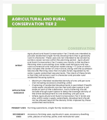
Both comprehensive plans, One Mooresville and 2045 Horizon, address residential (rural) agricultural zoning. More so, while Iredell County indicates that the 400 acres to be annexed was to remain rural and in the County's jurisdiction, One Mooresville provides a plan under rural residential and has a focus on ONE Mooresville with unity, connectedness, redevelopment of existing areas, reducing sprawl, while considering quality of life (aka Smart Growth). This comprehensive plan was a "community-driven" process with "broad outreach" and "input from hundreds of residents." One Mooresville wants "walkable streets with sidewalks" and considers "quality of life." The land to be annexed for the data center is disconnected and over a mile away. It is an island lacking any of the One Mooresville traits. The project is not consistent with ONE Mooresville, nor 2045 Horizon.
During the April 2025 Planning Board metting, some board members suggested that the annexation and rezoning might be justified by the idea that current town residents “pay town taxes and everything keeps getting more expensive.” While this may reflect a concern about rising costs, we believe that it is not a valid basis for land use decisions, and urge the Board to avoid this line of reasoning when evaluating the request.
Zoning and annexation decisions should be guided by comprehensive land use planning principles — not by fiscal convenience or the desire to expand the tax base. If decisions appear to be driven primarily by the town’s need for revenue, rather than compatibility with surrounding land uses, infrastructure capacity, or the Town’s long-term planning vision, it can erode public trust and give the impression that the Town is using annexation as a revenue-generating tool, rather than a strategic land use management process.
This kind of financial favoritism — where the needs of tax-paying residents within the town are elevated over the rights and concerns of those living adjacent to the disconnected proposed development — risks setting a precedent that undermines the fairness and objectivity of Mooresville’s planning process. It also fails to consider the potential negative impacts on neighboring rural residential areas, including traffic, noise, and changes to quality of life.
We encourage the Board to ensure that this decision, and future ones like it, are evaluated based on clear, objective planning criteria and consistent adherence to the Town’s comprehensive plan. Public confidence in local government depends on transparent, fair, and principled decision-making.


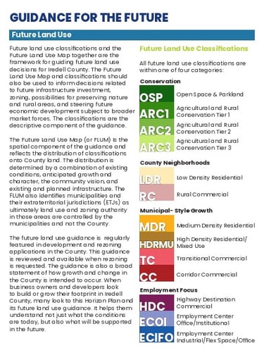
One Mooresville is the town's comprehensive plan that outlines a vision for Mooresville's future development. It guides the town's growth and development over the next two decades.
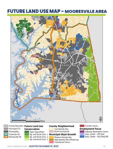
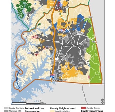
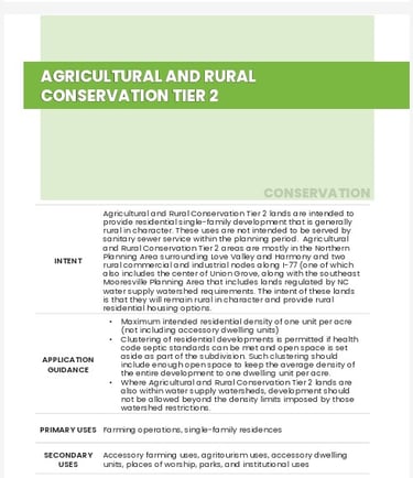
2045 is Iredell County's comprehensive plan that outlines a vision for future development. It considers: growth management and future land use, agricultural preservation, transportation, economic development, cultural, environmental, and water resources, & public services and facilities
Comprehensive Plans - Mooresville One and 2045 Horizon
Annexation from Iredell County to the Town of Mooresville

Mooresville Planning Board Information
The Mooresville Planning Board voted in favor of recommendation for rezoning from residential agricultural to industrial for a Mooresville Technology Park with no supporting data or studies.
Mooresville Planning Board Meeting Videos
The Mooresville Planning Board proposed draft of April 22, 2025 meeting board recommends approval to the town for rezoning while stating that the project is NOT consistent with One Mooresville (which was stated by Mr. Cole and was omitted from draft).
"A Sidewalk is required along Patterson Farm Road. However, this site is eligible to pay a fee-in-lieu at 100% of the cost of Sidewalk installation prior to site plan approval."
Project CZ-2025-004: 148 Patterson Farm Rd / 338 Rustic Rd (Mooresville Industrial Park)
Planning Board Staff Report
As part of the request for the proposed hyperscale data center presented to the Town of Mooresville (Project CZ-2025-04 Patterson Farm Road [Mooresville Technology Park]), specific items need to be considered when making amendments to the official zoning map as per Section 2.5.2.D of the Unified Development Ordinance (UDO). Below are five Decision Standards.
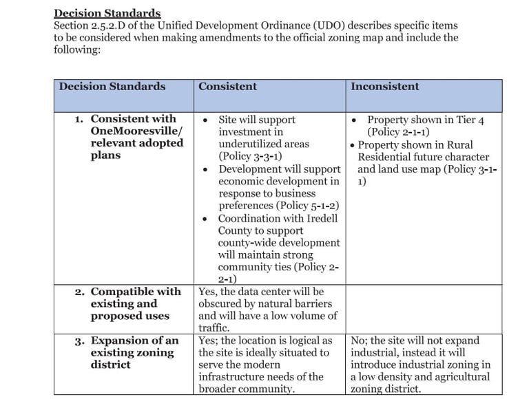
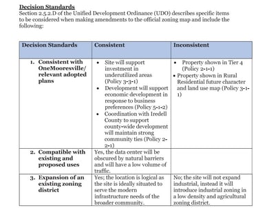
Taking a Look at Section 2.5.2.D of the Unified Development Ordinance: Decision Standards
Public Trust


Decision Standard One - Consistent w/ One Mooresville & Relevant Adopted Plans
Please read the One Mooresville policies used in Decision Standard One and deemed consistent with this project. There is particular emphasis on investment in underutilized areas, economic development in response to business preferences, and coordinating with Iredell County and maintaining strong community ties on the decision standards, however, read the true policies below:
Policy 3-3-1
Infill & Redevelopment Strategies Will Remediate and Revitalize Aging Investments
To maximize return on public investments and to foster cohesive placemaking efforts, the Town should support efforts to develop infill areas and redevelop and enhance aging developments.
Policy 3-3-1 Support Reinvestment in Underutilized Centers Facilitate the redevelopment and revitalization of the Town’s aging, blighted, and vacant activity centers. Revitalization of these centers can have a positive impact on community character and surrounding property values. Redevelopment and adaptive reuse of buildings located along activity corridors is encouraged and can be made easier through flexible design regulations that facilitate redevelopment. New infill development is encouraged on existing commercial sites.
Policy 5-1-2
Policy 5-1-2 Support Flexible Physical Development Standards to be Responsive to Business Preferences
Regulations will be reviewed to ensure employment areas are attractive for both businesses and employees. Increased flexibility in development standards will allow for more mixed-use areas and allow for the integration of office, research and development, maker spaces, and other innovative spaces. This includes allowing the transformation of office parks, strip commercial plazas, and underutilized industrial sites. Where industrial and manufacturing practices are not compatible with residences, flexibility will still be added to accommodate mid-shift services such as restaurants or convenience stores. Market changes will be monitored to ensure flexibility is sufficient to meet evolving business preferences. Even with the greater focus on flexibility, land will be protected for employment uses. These policies are supported through the guidance of the Future Character and Land Use (FCLU) portion of Chapter 3: Shaping Development.
Policy 2-2-1
Policy 2-2-1 Coordinate Planning and Zoning with Iredell County
Much of the lands within the Town’s planning area are currently within Iredell County’s planning and zoning jurisdiction. The Town should work with Iredell County during future updates to the County’s Comprehensive Plan and Zoning Ordinance to ensure that Mooresville’s Town Framework is reinforced by future County policies and regulations. In addition, consider creating formal relationships to coordinate planning in areas of common interest to ensure that planning policies on one side of the jurisdictional line match the policies on the other side.
Decision Standard Two - Compatible with Existing and Proposed Uses
The data center will have a roughly 1.5 million square foot footprint and has a maximum building height of 100'. Each building can be 30,000,000 square feet totaling 150,000,000 square feet of data center. There is a proposed 100' of buffer with trees that are less than 100' in height. In addition, the rear of the property appears to be highly visible to those residents on Archer Road.
"Yes, the data center will be obscured by natural barriers and will have a low volume of traffic"
Decision Standard Three - Expansion of an Existing Zoning District
We know that these are not local needs. We know that this 400 acres is located almost two miles from the closest current edge of the Town of Mooresville. We know that Iredell County did not know what this project was because of a non-disclosure and that it was originally set for the Back Creek watershed. We know that the residents in this area do not want utilities.
In planning and development, an infrastructure need refers to the essential physical systems and services that support the functioning of a community or area. These needs are vital for a development project to be viable and successful.
"Yes, the location is logical as the site is ideally situated to serve the modern infrastructure needs of the broader community."
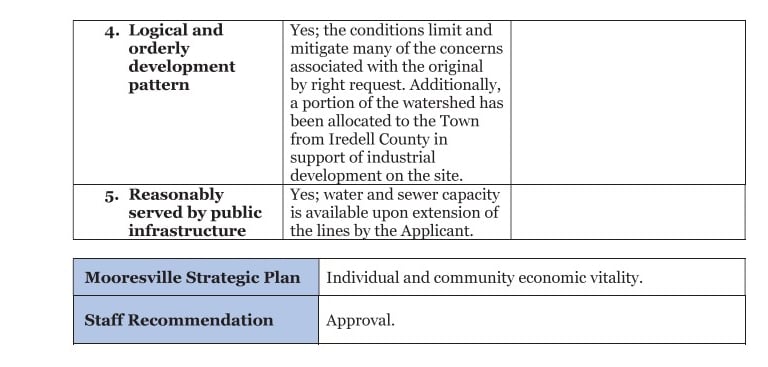
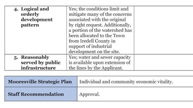
Decision Standard Four - Logical and Orderly Development Pattern
Just because one states that, "the conditions limit and mitigate many of the concerns" does not make it true. It is a logical fallacy. Residents have continued to state that they are not informed, that the conditions are too loose, that there is a huge lack of data and research, that the short and long term effects of a data center (based on research) are detrimental to the area. In addition, in December, 2024, the Iredell County Board of Commissioners stated that they granted land rights without any details of the project due to a nondisclosure.
"Yes, the conditions limit and mitigate many of the concerns associated with the original by right request. Additionally, a portion of the watershed has been allocated to the Town from Iredell County in support of industrial development on the site"
Decision Standard Five - Reasonably Served by Public Infrastructure
See Decision Standard Three.
"Yes, water and sewer capacity is available upon extension of the lines by the Applicant."
Consideration of the Town of Mooresville Strategic Plan
The Mooresville Strategic Plan is also considered by the Planning Board when approving or denying a project. Below is the qualifying category that the Mooresville Planning Board used to approve this hyperscale data center request. This overly broad category allows for superficial similarities that have significant differences. It lacks nuances and specific criteria that are essential for effective decision making.
Town of Mooresville Strategic Plan 2025
Individual and Community Economic Vitality
Foster strategic partnerships for economic prosperity
Assist sustainable business growth by leveraging local strengths and identifying new market opportunities for expansion
Pursue diverse economic drivers to foster a robust and varied economy
Support development of housing, employment, and educational choices to support economic sustainability
Town of Mooresville Planning Board Votes for Approval
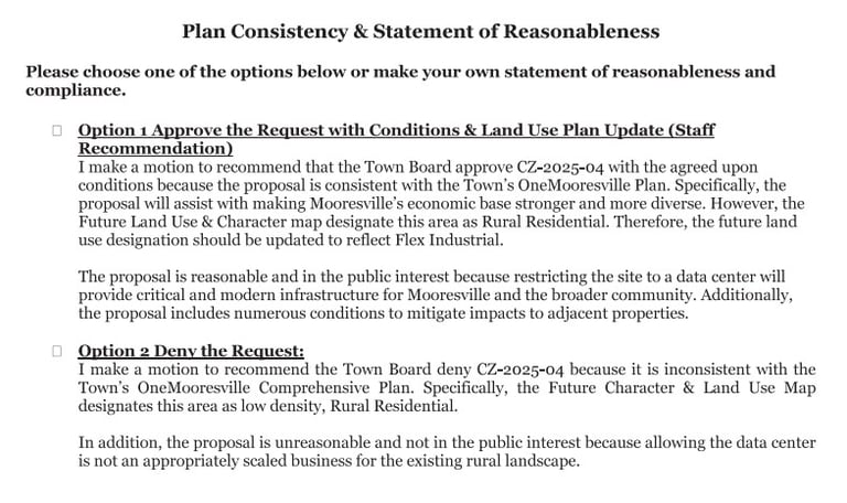
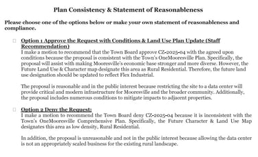
But Not Option One As Written


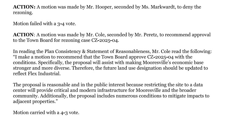
This is the form that was used to approve recommendation of the hyperscale data center project. A motion was made by Mr. Cole and seconded by Mr. Perez, to recommend approval to the Town Board for rezoning to flex industrial.
A motion by Mr. Cole to recommend approval included the following statements:
"I make a motion to recommend that the Town Board approve CZ-2025-04 with the conditions. Specifically, the proposal will assist with making Mooresville economic base stronger and more diverse. Therefore, the future land use designation should be updated to reflect flex industrial. The proposal is reasonable and in the public interest because restricting the site to a data center will provide critical and modern infrastructure for Mooresville and the broader community. Additionally, the proposal includes numerous conditions to mitigate impacts to adjacent properties."

Taken from Town of Mooresville Planning Board April 22, 2025 6:00 PM - Mooresville Town Hall
Draft Minutes
Mr. Cole's further explanation:
"I just want to point out that it is not exactly as option one. If the secretaries were taking track there, I did not read everything in that op... I just want to be sure that what goes in the record is what I said. So, are we good? You got it? Okay. Maybe the rest of the board needs to know what I left out. (asked for clarification) Sure. Sure. I'm not trying to be cute I just want to be sure people are following along. What you said, approving option one, it's not option one. I, I left out 'because the proposal is consistent with the town’s One Mooresville plan'; and I left out, 'however, the future land use and character map designate this area as rural residential.' I left that sentence out as well. So, that's what I scratched. And the 'therefore,' and the last sentence in the first paragraph stays in to, 'use designation should be updated to flex industrial.' I know it's kind of odd, but I think the Town Board is gonna have to figure this out. And a lot of good stuff has been said here tonight. I think there's a lot of value in restricting the use of this property to a very specific item. That's my personal opinion. That's why I voted against the first option. But it is not consistent with the plan."
(Asked specifically by chair, "so you struck on the first line, 'I make a motion to recommend that the Town approve CZ-2025-04 with the agreed upon conditions.' Stop.") "Correct. Correct"
("And then you pick up, 'Specifically, the proposal will assit with making Mooresville's economic base stronger and more diverse.' ") "Correct. Scratch the next sentence."
("And pick up with, 'Therefore, the future land use designation should be updated to reflect flex industrual.' ") "Correct."
("Thank you. And then the last paragraph?") "Stays the same."
("Okay.") "I apologize for the inconvenience." ("No. We appreciate your ..ation Mr. Cole. And thank you...")
Read the below transcript from the April 22, 2025 planning board meeting. The board chose option one, although noted that this was not option one... yet recommended that the Town approve this project.


Key Conditions Take Away
Development allows for less stringent standards if otherwise noted on the Concept Plan or in the Development Standards; If not mentioned in Concept Plan or Development Standards then more stringent standards apply; Must follow Ordinance for IN-zoning (although flex industrial zoning recommended).
The nature and location of the site elements can all be modified as long as they meet the new Ordinance standards.
Despite the planning board stating that this is a very specific zoning approval, the property may be developed for any uses permitted in the IN zoning. Accessory uses to support the permitted uses are also allowed. Accessory uses include, "enclosed energy, battery and fuel storage facilities" and "any other infrastructure necessary to support the permitted uses."
No concrete info regarding storm water, sound studies (other than before a building permit is provided; only monitored in decibels and averaged over an hour), light pollution (as security lighting does not have restrictions), energy use, water use, etc.
A gate may be installed on Rustic Road.
There are two "preservation areas" that may or may not occur. One may allow Coddle Creek ARP Church to use as a cemetery.
Only 100' buffer for buildings that can be 30,000,000 cubic feet or more, EACH, totaling 150,000,000 cubic feet.
Maximum building height of these roughly 1000'x300' buildings is 100'.
No sidewalk needed. Pay a fee-in-lieu at 100%.
Areas of the building that are visible from the road need to have 2 elements with colors that blend into the surrounding natural environment. Architectural modifications set forth in Section 2.5.23 of "the Code" may be granted.
Chain link fencing with slats is not acceptable, however, a 14 foot chain link fence with mesh has been accepted.
Concerning conditions that the Planning Board stated will mitigate impact to adjacent properties:
Associated Mooresville Information
Video of markings on road from the sewage treatment plant on Johnson Dairy Rd to the proposed site on Patterson Farm Rd despite the BOC not yet officially approving the rezoning and annexation.
Associated Iredell County Information
Iredell County grants annexation and valuable building / land rights to the Town of Mooresville, without details nor public notice, as it was not a legal requirement.
Iredell County residents respectfully ask for the Iredell Board of Commissioners to require detailed information, and provide public notice, in all annexation and watershed building rights requests.
No Clear Plan or Planned Confusion?
Rezone, Flip, Leave, Repeat


In an article for Data Center Dynamics, Tract employee, Mr. Van Rooyen, states that, "Tract won’t be engaging in building its own data centers," and instead focuses on "acquiring land, taking it through rezoning and entitlements so that data centers are allowed by right on the land..."
What does this translate into in the real world? Click on these video links from Farmington, MN and watch for the parallels to what is happening in Mooresville and other areas around the nation.
From DataCenterDynamics.Com:
✔ Confidential - unnamed developer planning to purchase large acreage for technology or industrial site. Many times cities or towns agree to sign a non-disclosure limiting transparency to residents.
✔ Steam rolling land rezoning. Developer moves fast in requesting zoning change. No incentives told to the public. Very little time is provided to residents to find out about the project and citizens do not get a clear understanding of the impact of the approval.
✔ Developer claims to have no knowledge of the intended end user.
✔ Environmental impacts and zoning incompatibilites are not fully addressed and most often dismissed.
✔ Local govenments, promised tax base and jobs, approve rezoning with many of the future details of the project unknown.
✔ Board questioned about lack of proper notice to residents. Residents state they did not receive notices that company says they sent.
✔ Board finds little to criticize. Residents share concerns with rezoning. Developer downplays citizens concerns and why their concerns hold little merit. They sell good neighbor values.
✔ Questions regarding when the town knew about the project and when residents were told about the project.
✔ Conditions imposed by town are too flexible and board sees the tax revenue the project can generate rather than how the residents and environment can be impacted.


"Tract"ing the Similarities with Farmington:


Mooresville Roots
"The Dale Earnhardt Foundation’s mission is to continue Dale’s legacy through charitable programs and grants that sustain his lifelong commitment to Children, Education and Environmental Preservation.”
Benefits V. Cost
Tract's Lasting Benefits of Data Centers
According to Tract's website, the lasting benefits of data centers are: property tax influx, skilled job creating, low impact industrial activity, thougthful land stewardship. They are highly automated, partner "with a leading solar developer to pre-position renewable power generation married to the data center land and encourage the transition to cooling designs with lower water consumption."
The Cost of Data Centers
Community Feedback
The proposed rezoning threatens our agricultural land and local environment significantly.
John Smith
Mooresville NC
We strongly oppose the rezoning. Protecting our environment is crucial for future generations. Data centers use too much water.
Brenda Jones
Mooresville NC
★★★★★
★★★★★
You didn’t come this far to stop
On Behalf of the Residents of Patterson Farm Road and Surrounding Communities.
copyright 2025
awareness
protect
people first